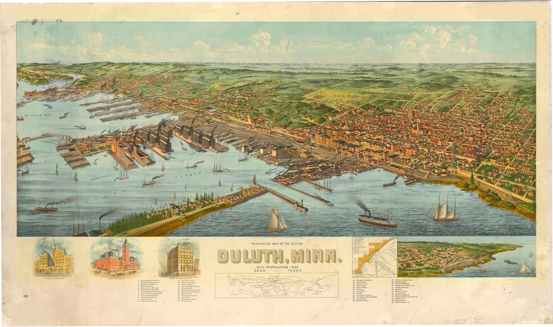
A steamer entering Duluth in 1893 came through a cut in Minnesota Point with stone piers on each side and a line of docks ahead. The water opened into Superior Bay, where elevators, slips, and ore docks stood in ranks at Rice’s Point. Smoke drifted from tug stacks. Streets climbed the hill behind the harbor in terraces of brick blocks and wood houses, as if the town had been hauled uphill from the water by rope.
The 1890 census counted 33,115 people in Duluth. Twenty years before, the port had just received its first train on the Lake Superior and Mississippi Railroad, and the cut through Minnesota Point had joined St. Louis Bay to Lake Superior. Those two works changed everything. The Port of Duluth-Superior notes that by 1891 grain elevators in the harbor had passed one million short tons shipped. Wheat from Minnesota and the Dakotas came east to this cold corner of the lake, then went forward by boat through the Soo.
Iron pushed the city harder in 1893. MNopedia notes that the Merritts finished the Duluth, Missabe and Northern line and built what were then the largest ore docks in the world at Duluth that same year. They did it with borrowed money as the Panic of 1893 set in. That tension sits inside the sheet itself. Its title block boasts a rise from 5,000 people in 1873 to 70,000 in 1893, even though the nearest federal census put the city at 33,115. Duluth was selling its future as fast as it shipped grain and ore.
American Publishing Co. issued the panorama as a civic argument. The Library of Congress notes a list of numbered points, two ancillary maps, and a small view of lakeside Duluth. The main image puts the harbor first: canal piers, slips, grain elevators, rail yards, and the long industrial front at Rice’s Point. Homes, churches, and public blocks spread up the hill behind them, but they do not control the composition. The city is there because the harbor machine is there.
That is why the sheet belongs to 1893. It shows Duluth at the moment when rail, canal, grain, and new ore traffic made the port look immense, and when debt and booster claims pushed that image past the census count and toward a bigger future.
Themes
On the sheet
- Duluth Ship Canal and the harbor piers
- Rice's Point grain elevators and rail yards
- Superior Bay slips and docks
- The hillside street grid above the waterfront


