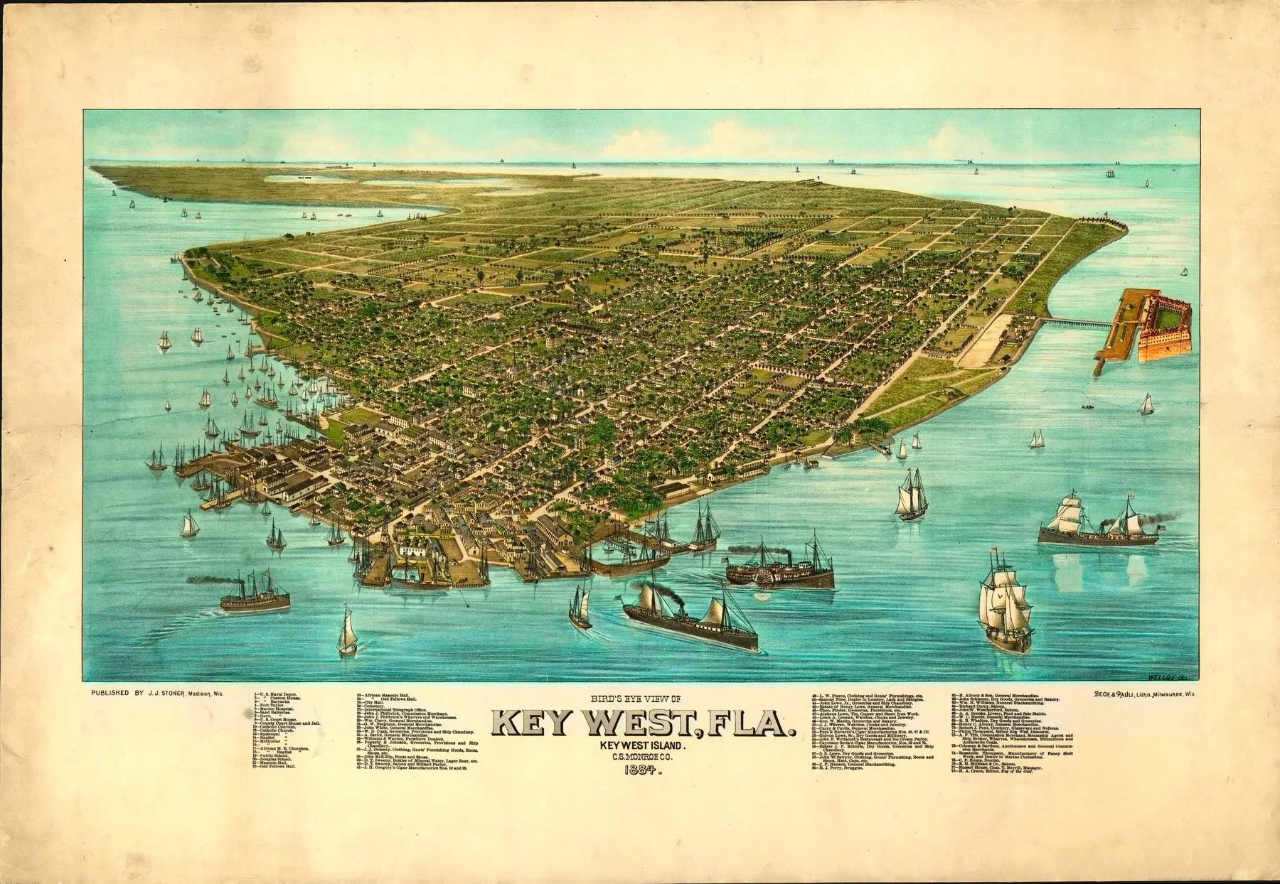
The ship would have entered through water that looked empty from a distance and crowded at close range. Masts, warehouses, small boats, and the low masonry of Fort Taylor sat against a flat island with almost no rise to hide behind. By 1884, anyone stepping ashore at Key West came into a town built out of harbor work, federal presence, and the pull of Cuba.
By the 1880 census, Key West had 9,890 residents, and local historians note that it had become Florida’s largest city. That still catches people off guard. The island now arrives in most minds through writers, bars, and late light, but in the nineteenth century it mattered because it sat at a hinge point between the Gulf, the Straits of Florida, and Havana. The naval station at Key West dated to 1823, and Fort Taylor guarded the harbor that made the island useful to Washington.
Work on the island came in several forms, and none of them was ornamental. Florida Memory notes that Vicente Martinez Ybor opened a cigar factory in Key West in 1869. He moved the operation to Tampa in 1885, which places this 1884 map at the end of Key West’s first cigar age, when Cuban exile capital and Cuban labor had already changed the blocks behind the waterfront. The Key West Citizen had begun publishing in 1879. The harbor still fed the town in a direct way. Dry Tortugas National Park’s account of the old Thompson Fish House points back to a waterfront where the local fishing fleet landed and processed each day’s catch. This was a port city in the old sense, where life still depended on what came off boats.
J. J. Stoner’s bird’s-eye view makes that dependence visible. The sheet is indexed for points of interest, and the Florida Center for Instructional Technology notes that it shows the streets, harbors, naval depot, Fort Taylor, and salt ponds from the west-facing waterfront. The salt ponds matter. They place Key West in the years when the island still turned evaporation into one of its trades. The naval depot matters for a different reason. It tells you the town did not grow as an inland Florida settlement that shifted seaward, but as a maritime outpost whose street grid hugged federal ground, commercial wharves, and open water.
Two years after this view was published, the fire of 1886 would alter much of the city’s wooden building stock. The map catches the island before that break. Stoner did not draw a tropical refuge. He drew a working edge of the republic, and that choice tells you how Key West wanted to be seen.
Themes
On the sheet
- Duval Street commercial district
- US Naval Station
- Cigar factory district
- Key West harbor


