A boat coming up the Savannah River in March 1734 reached the bluff before it reached the town. The bank rose hard from the water, fenced at the top, with a few raw roofs and timber frames set against a wall of pine. Men worked the landing below while the river carried canoes and a square rigged vessel past the cut earth. Above them, in a clearing hacked from the woods, straight lanes and rectangular house lots ran with a precision the country around them did not share.
Savannah was not yet a year old, yet it already held a mix few British outposts could match. After James Oglethorpe secured terms with Tomochichi and relied on Mary Musgrove as interpreter at Yamacraw Bluff, the Trustees tried to build Georgia around small freeholders and mercantile trade rather than Carolina’s plantation order. The colony’s second ship brought a Jewish community large enough for Oglethorpe to set aside a burial ground, and physician Samuel Nunes became one of the people who kept the settlement alive in its first sick season. In the spring of 1734 the first Salzburgers reached Savannah before moving to Ebenezer upriver. For a place that still looked half built, it had already become a meeting ground for English settlers, Jews from London and the Iberian world, German Protestants, and Creek diplomacy.
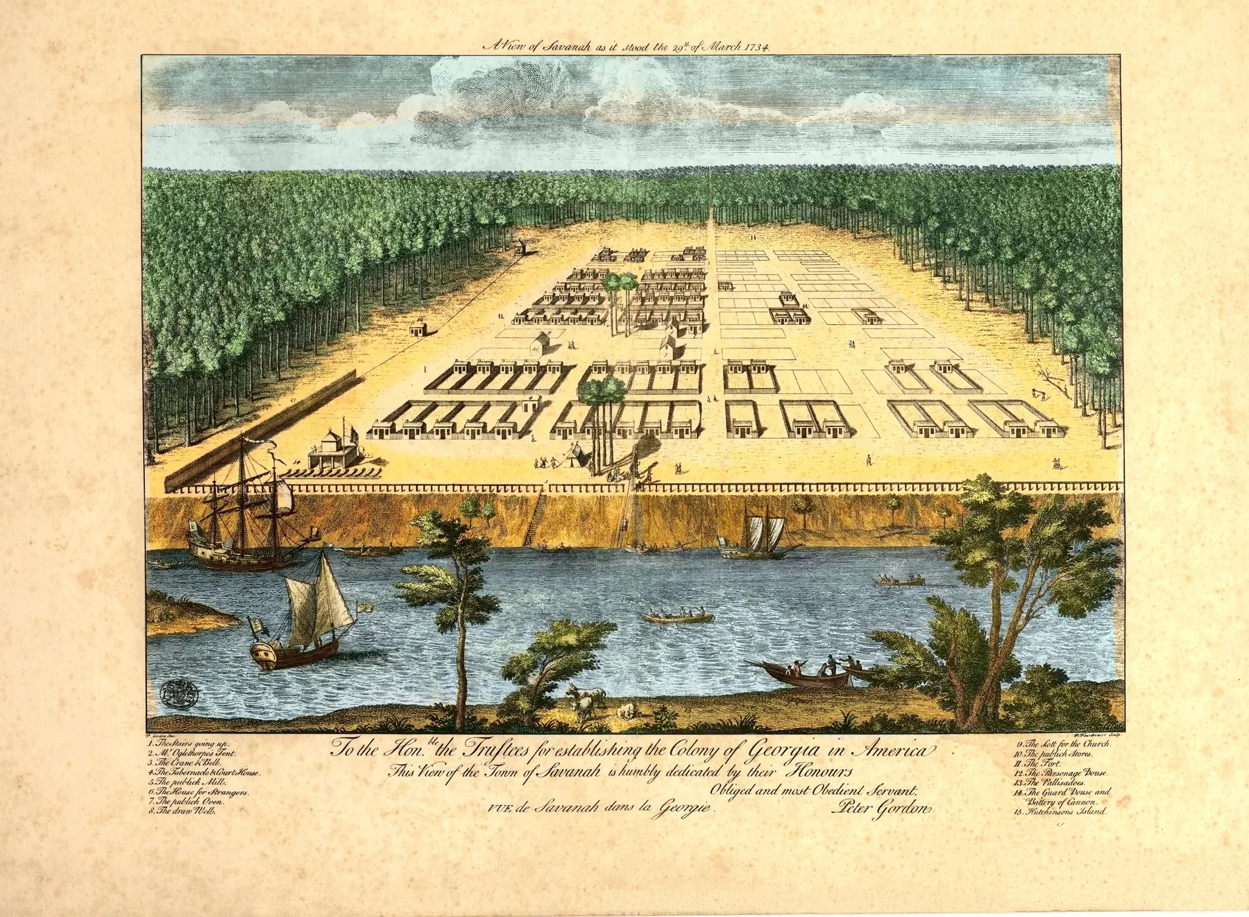
The plan on the ground was as striking as the mix of people. New Georgia Encyclopedia notes that the town stood on a forty foot bluff and arranged each ward around a square, with trust lots for public buildings and tything lots for houses. Savannah’s tour guide manual identifies the first four wards south of Bay Street as Decker, Derby, Heathcote, and Percival. That wasn’t decoration. Each square gave the town common ground and a place for defense, which meant the neat geometry served muskets as much as manners. Savannah’s regularity came from military need, social theory, and land discipline at the same time.
Peter Gordon drew the sheet as a colonial plan under strain, not as a settled port. The Library of Congress title fixes the date as 29 March 1734, and the image gives the river the whole foreground, the bluff like a rampart above it, and the settlement as a measured field inside the forest. Palisades line the edge. Cleared lots sit beside open ground still waiting for buildings. Boats crowd the water while the town behind them remains sparse enough that you can feel how much labor and faith the grid still required.
On 29 March 1734 Savannah still looked like a claim cut into the pine woods, and Gordon drew it in deliberate order, exposed by fact.
Themes
On the sheet
- Savannah River waterfront
- The original four wards of Oglethorpe's grid
- Palisade fortifications
- The bluff above the river


